


Woolpert Geospatial Sector Leader and Senior Vice President, Joseph Seppi, delivered a thought-provoking plenary session at the 2023 Locate Conference, in Adelaide, Australia. Below is a summary of this presentation titled ‘Geospatial Evolutions – From Map to Multiverse?’ – a testament to Woolpert’s global geospatial expertise.
Joe started by addressing the elephant in the room – making jest about articulating the phenomenon that is geospatial. He explained that the word geospatial is often followed by industry, market, profession, ecosystem, and community to name a few; but the nature of geospatial can be complex and unclear.
Geospatial doesn’t fit nicely into an industry or even an industrial sector. In fact, geospatial is not listed in the North American or the Australian and New Zealand Industrial Classification Systems (NAICS) (ANZSIC). Actually, the word ‘geospatial’ doesn’t even appear. The same can be said for the EU classification of Economic Activities (NACE), the UK Standard Industrial Classification (SIC), and even the United Nations International Standard Industrial Classification of All Economic Activities (ISIC Revision 4).
Likening this to an identity crisis, Joe proposed that geospatial is a market composed of consumers, sellers, commodities, and prices. What we call the ‘geospatial industry’, is merely a part of many distinct industries in different sectors.
Joe then shared some of his deep history within geospatial. He was introduced to GIS in 1989 by the late Ian McHarg, known for his pioneering work in the Environmental Movement and academic practice at Harvard, University of Pennsylvania, and Penn as a prime mover of GIS. McHarg became an employer, mentor, and graduate academic advisor to Joe, working together on planning projects using an early form of GIS – maps drafted on acetate drawn with Rapidograph ink pens.

The McHarg Center. Ian L. McHarg [Photograph]. Weitzman School of Design, University of Pennsylvania. Ian L. McHarg | The McHarg Center (upenn.edu)
“My very first impression about GIS was that we had this incredibly powerful tool, but there was very little digital data to digest. Most of what we needed was on paper,” Joe said. “If you wanted good accurate mapping, you had to get out and survey or digitise.”
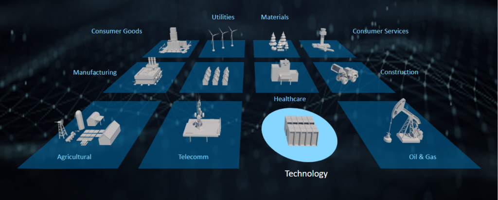
Fast forward to the present day, much of what we do depends on emergent technologies, and sometimes they depend on us. Hitching a ride on the digital revolution, ‘geospatial’ roots can be hard to place. Joe gives credit to the geospatial phenomenon and its origins in the scientific and government domains, now found in just about every industry with varying levels of maturity.
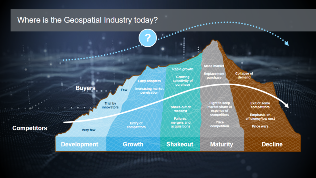
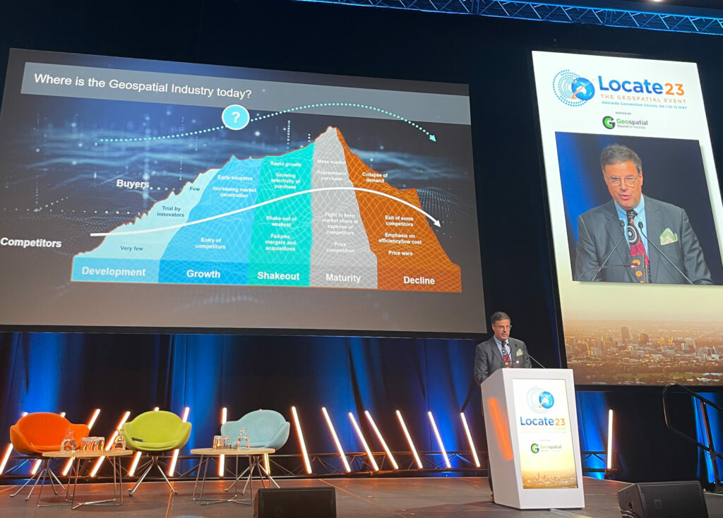
“Geospatial is in a state of high entropy,” Joe said. “Imagery, for example, is very mature as part of the data ecosystem; Lidar is newer, and GIS and navigation are each at different levels of the maturity curve.”
Industrial ambiguity and the rapid emergence of competition with lower barriers to entry, led to changing government acquisition posture, and reduced demand for licensed professionals.
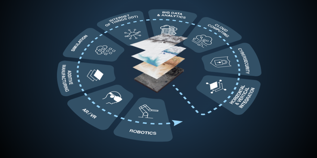
All in all, the ultimate product of geospatial is ‘location,’ and entire supply chains exist to answer the question of where? To answer this, geospatial data is paramount. The future will see AI, digital twins, the metaverse or multiverse needing near real-time updates, with a steady supply of exquisite high resolution geospatial data critical to this movement.
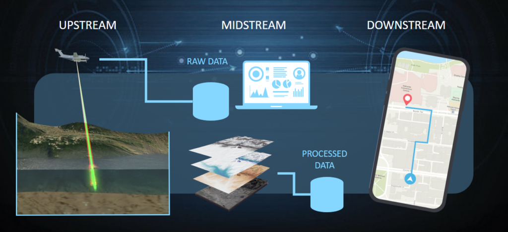
Referencing David Alexander, former GIO at the U.S Department of Homeland Security, Joe drew parallels of geospatial information to the utility sector, as a “vital need, deemed by state and federal lawmakers to be in the public interest…” and potentially regulated but not “owned” by government. He further explores this through upstream, midstream, and downstream market segments, highlighting the need for a robust midstream market that will make data collectors less dependent on government applications and revenues.
Joe concluded his Locate23 plenary address with his thoughts on the potential for democratising geospatial data and stating that “geospatial is an adjective, but when used as a noun – it is a phenomenon.”
- Increasing velocity driven by data-hungry deep learning models and increasing numbers of downstream use cases.
- Higher resolution
- Less dependent on government applications and revenues
- Moving from a professional service to product business models
- Capital intensive, increased asset utilization, as prices decrease
- Requires a healthier marketplace for data, less lumpy, with better price modulation
- Don’t assume that what works today will even be relevant tomorrow
- Many new entrants and niche players are and will aggregate data, provide curated outputs, offer maps and location data at scale, and maintain rich 3D models, twins, metaverses or whatever.
- These are the refineries that convert raw data like lidar point clouds, into information.
- These are the enterprise, desktop, and mobile software applications or apps.
- There are new use cases are coming online every day… this is where the growth will be
- Price sensitive, and able to find multiple solutions to solve the “same” problem
- The biggest use cases in five years may not exists today
- Looking for open solutions that are not dependent on technical know-how
- Looking for answers, not data, and probably not just “content”
Joseph Seppi
Geospatial Sector Leader and Senior Vice President
A visionary leader in the industry, Joseph Seppi expanded Woolpert’s Geospatial Services globally and into new market segments. Joe is a senior vice president at Woolpert and leads its geospatial business consisting of nearly 1,000 employees across five continents. He has 34 years of technical, program and project management experience in photogrammetry, advanced sensors, enterprise systems, and business management. Over his career Joe has pushed the envelope on current geospatial technology and industry paradigms to solve complex challenges.

 (1)")
")
")
")
")
")