


The COVID-19 pandemic has accelerated an ever-increasing need for improved digital services. Citizens and employees need remote, digital access to nearly every service imaginable, and government entities of all sizes are tasked with meeting these needs.
Questions never pondered are now asked regularly – what Local Government Area (LGA) am I in? How will my shopping delivery get to me? Where can I travel from my home bubble? Where is my nearest testing or vaccination centre? Where is the location of that city park? Getting answers to these types of questions and allowing people to access them quickly requires location data, delivered intelligently with geographic information systems (GIS).
GIS supports many services that benefit local communities from land management and property assessment to utility services and infrastructure maintenance, emergency management and pandemic recovery. GIS provides crucial location intelligence that supports local governments in analysing and understanding their communities. It gives local leaders the ability to visualise their communities’ areas of strength and weakness and provides for easier information sharing with residents and the community.
To effectively gather, analyse and deliver this information, GIS professionals rely on a mix of technology and intelligence gathered in the community. GIS professionals and employees in the field both need access to data they can trust. Time, connectivity and accuracy matter.
Field employees face the dual challenges of both capturing and reporting on key data in varying environments. Often this work is performed in places with limited or no internet connectivity. Adding to their challenges is the need to work around the limitations of existing field data collection applications.
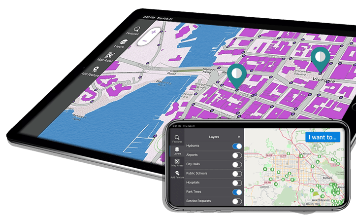
Fortunately, there is mobile-friendly GIS solution that allows users to build, review, edit, and submit information in both online and offline environments without needing to resort to custom coding.
VertiGIS Studio Mobile is the next-generation mobile viewer framework that empowers users to develop cutting-edge field data collection apps and run them online or offline. It provides an innovative approach to mobile application development that is fully aligned with Esri’s roadmap. Importantly, users have clearer oversight of their assets in the field with data they can trust.
Mapping valuable tree assets in the cloud
Located in the Hunter region of New South Wales, the City of Newcastle is a local government area with a population of 348,359. The City of Newcastle covers an area of 187sqkm and manages a vast network of facilities and infrastructure including 850km of roads, 974km of pathways, 147 sporting grounds, 116 playgrounds and seven ocean baths and aquatic centres.

With over 70,000 trees on public streets and hundreds of thousands more within Newcastle’s local government area, the City of Newcastle is acknowledged as a leader in urban tree management.
The City of Newcastle recently chose VertiGIS Studio Mobile, over competing solutions, to help them manage their trees which they consider to be significant capital assets. Using VertiGIS Studio Mobile, the City’s GIS professionals developed a tree management app that was both fit for purpose and straightforward to use.
VertiGIS Studio Mobile enabled City of Newcastle to visualise and maintain their trees by empowering employees to identify, locate, inspect and maintain assets
The City also benefits from being able to fully map their business processes to technology, rather than having to compromise and adapt their business processes to fit technological limitations.
Watch this short video to see how the City of Newcastle uses VertiGIS Mobile
Using GIS to take the guesswork out of decision making
Smart use of GIS increases capacity for data-driven decision making. By accessing geospatial data and visualising it on a map, governments can take the guesswork out of economic and urban planning efforts or identify trends across areas where something has changed. This in turns help their communities to have access to reliable and accurate spatial information.
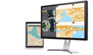
Modern mapping software, such as VertiGIS Studio, helps organisations operate more efficiently, communicate more effectively, and improve decision making. VertiGIS Studio enables GIS operations to be streamlined with ease and puts more granular control in the hands of users. This includes cloud-based delivery of map viewers, streamlined reports, and high-quality printing. Importantly, users can build and configure purposeful, powerful mapping and GIS applications without writing a line of code.
VertiGIS Studio is in use by more than 1,400 organisations around the world and is distributed exclusively in Australia and New Zealand by AAM, AAM also provides consultation, implementation, training and customer support services for VertiGIS Studio software.
AAM, a Woolpert Company will host AAM Live21 – its annual VertiGIS Studio product forum, on Wednesday 24 November at 12.00pm AEDT. During this event you can hear from the specialists at AAM and VertiGIS Studio. Several VertiGIS Studio customers will also detail how they have built applications that tackle complex problems to make a meaningful difference in the world.
Register and discover how AAM and VertiGIS Studio Mobile can assist with your field-based GIS needs at aamgroup.com/aamlive21. Alternatively visit our Geospatial solutions page to see how your organisation can benefit.
 (1)")
")

")
")
")