Home » Products & Services » Land Survey » Engineering Surveys

Engineering Surveys

Get highly accurate answers, quickly.

Save time and money with efficient, high-precision data delivery

Engineering surveys can be a necessary evil. You need to carry out surveys to look out for faults in your equipment and maintain its performance. At the same time, a survey can mean equipment downtime and a consequent loss of production time.

Don’t take your chances with a sub-standard engineering survey that leaves you hanging. Slow processes can be very expensive.

Woolpert’s engineering survey service is defined by its expertise and speed. Backed by 60+ years of experience in the Asia-Pacific region, our team always strives to get you accurate answers in the shortest time frame possible.

Why Woolpert?

Any site, any time

Request surveys of any site, at any time of day and we’ll be there. The Woolpert engineering survey team is your on-call data collection and delivery team.

Immediate data delivery

Get your data in hand, analysed by our experts, while we’re on-site. No post-survey delivery delays.

Complexity, made simple

Understand your complex survey data better and learn how to put it to use in business, with the help of our expert engineering survey team.

“Woolpert has been integral in the creation of our enterprise wide GIS solution. This is a powerful technology enabler that will allow our staff to be connected to data in new ways. Woolpert’s collaborative approach and thought leadership was a cornerstone to the success of the strategy. We’re thankful for the close and supportive partnership that we have with the Woolpert team during this project.”

GIS & BIM Manager

Aviation

“The model is absolutely exceptional. The quality of light was perfect. The team went above and beyond our expectations with the awning work and detail. We are very impressed and excited to use this for several of our new public spaces planned over the next few years.”

Senior Urban Designer

Local government

“Very happy with the accurate, detailed and functional 3D Building Models we sourced from Woolpert’s Geocirrus. Our software was readily compatible with the formats provided by Woolpert. These models have been instrumental in contextualising and analysing sites in our design process.”

National Sector Lead

Architect firm

“Thank you for the extraordinary effort in bringing the rail project across the line on time. Your team and dedication to the project has been recognised across our organisation and we would like to keep strengthening our business relationship with Woolpert in future projects.”

Civil Engineer

Civil engineering & construction company

“A very successful imagery capture – the limited shadow in particular was exactly what we are after (the parameters of which would be ideal for all future captures). The colour temperature and overall quality of the mosaic is also excellent.”

Senior GIS Analyst, Spatial Services

Local government

“One definition of integrity is ‘doing what you said you would do, when you said you would do it’. I think Woolpert’s work fits this definition very well.”

John Gibson

Senior GIS Analyst, Greater Wellington Te Pane Matua Taiao

Previous
Next

Work with Australia’s fastest engineering survey team

Woolpert’s engineering survey team is backed by 60+ years of hands-on field experience in the Asia-Pacific. We are known for our speed and our attention to detail.

Need data delivered on the same day? No problem. Our survey experts can crunch the data by hand and have it ready for you while on-site.

An experienced team, first-class equipment, quality processes, and rapid data delivery mean our clients always get the best results from their engineering surveys.

Our land survey projects in action

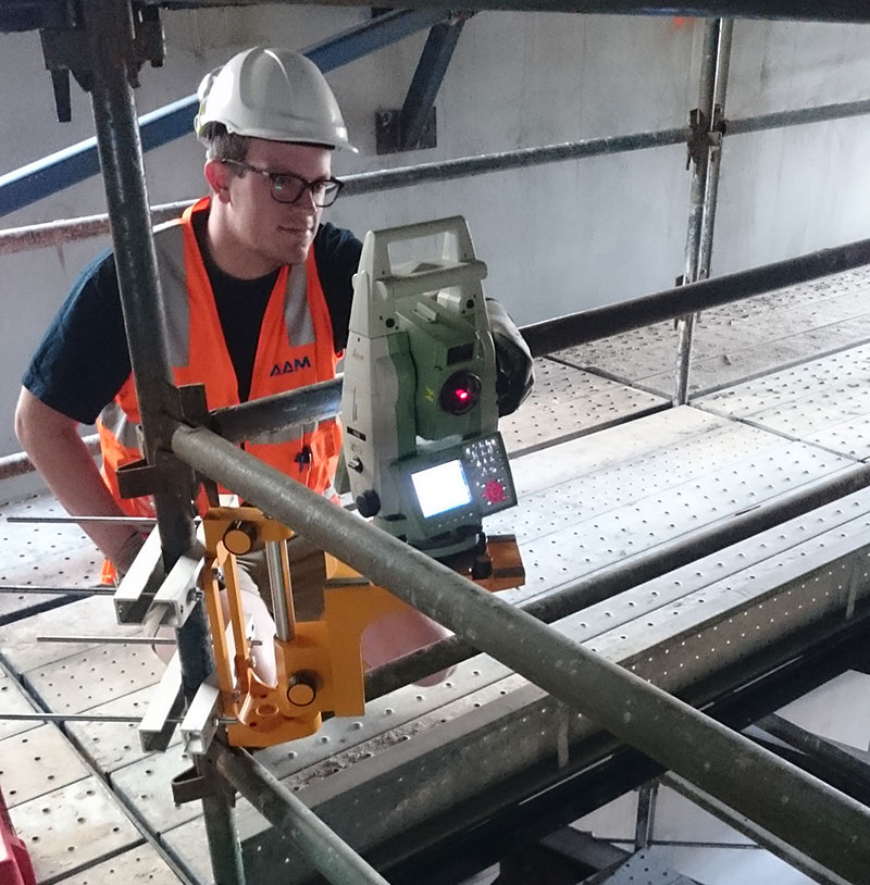
Terrestrial Laser Scanning for the University of Melbourne

The University of Melbourne undertook redevelopment work to its site. In particular, the Old Commerce Building was demolished. Due to its façade being of significant heritage value, it needed to be retained whilst the remainder of the building was demolished. It was imperative that the construction works did not cause any movement and potential damage to the façade during the demolition of the building and the erection of a façade retention structure.

   Read more
“Woolpert has been integral in the creation of our enterprise wide GIS solution. This is a powerful technology enabler that will allow our staff to be connected to data in new ways. Woolpert’s collaborative approach and thought leadership was a cornerstone to the success of the strategy. We’re thankful for the close and supportive partnership that we have with the Woolpert team during this project.”

GIS & BIM Manager

Aviation

“The model is absolutely exceptional. The quality of light was perfect. The team went above and beyond our expectations with the awning work and detail. We are very impressed and excited to use this for several of our new public spaces planned over the next few years.”

Senior Urban Designer

Local government

“Very happy with the accurate, detailed and functional 3D Building Models we sourced from Woolpert’s Geocirrus. Our software was readily compatible with the formats provided by Woolpert. These models have been instrumental in contextualising and analysing sites in our design process.”

National Sector Lead

Architect firm

“Thank you for the extraordinary effort in bringing the rail project across the line on time. Your team and dedication to the project has been recognised across our organisation and we would like to keep strengthening our business relationship with Woolpert in future projects.”

Civil Engineer

Civil engineering & construction company

“A very successful imagery capture – the limited shadow in particular was exactly what we are after (the parameters of which would be ideal for all future captures). The colour temperature and overall quality of the mosaic is also excellent.”

Senior GIS Analyst, Spatial Services

Local government

“One definition of integrity is ‘doing what you said you would do, when you said you would do it’. I think Woolpert’s work fits this definition very well.”

John Gibson

Senior GIS Analyst, Greater Wellington Te Pane Matua Taiao

Previous
Next

Track long term business performance with consistent data delivery

Engineering surveys are key for equipment performance and maintenance. They’re also important to get a holistic view of equipment performance over a period of time.

Consistently carrying out these surveys with Woolpert ensures the same level of quality on data delivery. This will enable you to track the performance of your equipment and output rates over the long term.

Keep an eye on your long range business performance and improve decision making with accurate and precise data delivery year-on-year.

Frequently asked questions about engineering surveys

There are many factors that determine when we can fly to capture your LiDAR data which can impact cost, such as:
* Air traffic control restrictions
* Weather conditions
* Tidal flows
* Angle of the sun
* Availability of the right aircraft and the right sensor for the job

Other factors that affect the cost of your airborne LiDAR survey include:
* Size of the survey area
* Distance of the survey area from air base
* Terrain conditions
* Level of accuracy required (which in turn is influenced by how you intend to use your LiDAR data)
* LiDAR processing considerations: larger and/or more complex data requires more time, computing power and/or human intervention to process.

Like any flight, our departure times depend on the weather.

We must also factor in our current pipeline of work and equipment availability. But if you need your data urgently, we have different options to meet your need. Talk to us about your project and we’ll work out a solution.

With our efficient LiDAR processing system, you can get your data quickly . Most projects take a few weeks to a few months depending on how much data there is, and how many servers are needed to process the data. We can put more servers on the job if you need the data urgently. 

With UAV LiDAR, we can get up to 2000 points per square meter of resolution. With fixed-wing LiDAR we can get about 1-50 points per square meter of resolution, with an accuracy of <10cm. But your project might not need all the data we can get. The level of resolution and accuracy needed depends on the problem you need to solve and how you plan to use your LiDAR data.

We can supply these formats:

TIFF, ECW, RAW (full list coming)

We can translate the data to any format so if your required format is not listed here, get in touch. We can probably deliver in the format you need.

When deciding on whether UAV/drone technology is needed for a project, we consider the location, the size of the area being surveyed, and the resolution required. Some projects don’t need the type of clarity achieved through UAV. Some projects benefit with fixed-wing AND drone LiDAR. What we recommend, depends on the problem and the result you need.

Yes! Geocirrus (link to store) is our catalogue of premium geospatial data. In addition to LiDAR data we have aerial imagery, 3D models and mesh.

We supply the data under AAM’s license or to our clients’ IP.

Once our clients have received and accepted our priced proposal for their project, we initiate a formal project handover. A dedicated project manager talks to our client to clarify that both sides understand the aim and scope of the project. We schedule the appropriate aircraft and sensor to start gathering data, whilst sending regular updates to our clients as each major milestone is reached. Once all the data is captured we send it to our processing team. We process and translate the data into our client’s preferred format, then deliver it via a cloud-based platform or hard disk drive.

Get fast, accurate, and valuable engineering survey results.

Contact us to see how we can help you capture and analyse your data.

Let us help you find what you're looking for:

GIS Support

If you are an existing client requiring support for your VertiGIS Studio, GIS or application development solutions – please submit a query below: