Airborne LiDAR & asset modelling for effective powerline vegetation management
Power Line Monitoring for the Energy Sector
The safe operation of its 11,000 plus kilometre transmission network is the highest priority of this transmission owner and operator. With assets located in high fire danger areas, and sections of densely vegetated transmission line corridors at risk of bushfire, risk minimisation is an integral part of its asset management strategy.
The Challenge
Improving vegetation management to reduce bushfire and outage risks
Inspecting assets and powerlines for vegetation and easement encroachment from the ground is slow and expensive. Inspection through aerial survey saves time and cost and would be used to:
- Detect vegetation easement encroachment
- Execute maintenance work related to conductor-to-vegetation clearances in all environmental conditions and loadings
- Develop maintenance programs for effectively removing all infringement vegetation based on growth rates
- Preparing work orders for maintenance crews
.
The Solution
AAM’s LiDAR network mapping services, powerline and vegetation modelling and work order automation comprises these key functions and benefits
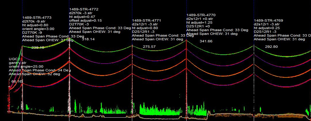
- Precision LiDAR mapping – acquire high definition vegetation and asset data across the transmission network
- Power line modelling – build power line models with PLS-CADD using LiDAR data, load levels and weather conditions
- Vegetation profiling – identify current and, by incorporating growth rate data, possible future vegetation infringement
- Tailored scenario modelling – predict possible vegetation infringements under ‘typical’, ‘excessive’ and ‘maximum’ line load and weather conditions
- Efficient processing of maintenance work orders – streamline maintenance contractor work orders to meet the organisation’s asset management standards
The Results
AAM’s powerline mapping and modelling improved vegetation management,
increased staff deployment efficiencies and minimised risks by:
- Prioritising vegetation maintenance tasks to enable more efficient maintenance crew deployment
- Identifying priority infringements and creating typical to maximum conditions for risk mitigation strategies
- Creating a complete set of PLS-CADD transmission line models, ready for use in future maintenance and management tasks
- Creating a detailed, auditable vegetation management program that meets organisational, board and industry regulator standards
- Reducing the risk of power outages, infrastructure damage and bush fires