


Gold Coast Water Authority GIS Management
Enhancing community engagement through interactive GIS functionality
Gold Coast Waterways Authority (GCWA) is the statutory body that manages the extensive waterways of Queensland’s Gold Coast from south of the Logan River to the New South Wales border.
The 10-year GCWA Management Strategy calls for greater access to waterways, alongside the creation of safe areas. To achieve this, GCWA proposed a set of speed limit changes and engaged the community through an interactive map to determine public opinion.
The Challenge
GCWA required a community consultation solution with contextualised feedback.
AAM assessed GCWA’s needs as:
- Gathering public opinion through a web mapping application that identifies the spatial location of areas marked with feedback in real time data so that users can share information
- Creating a conversation with the community and key stakeholders to achieve collaborative engagement
- Enhancing user experience and increasing engagement througha responsive online interface, accessible on all devices and web browsers
- Improving the quality of data and accuracy of reporting
- Using a fully hosted solution
The Solution
AAM worked with GCWA to design and deliver a web app that allows users to log in and submit location-specific comments in relation to proposed speed limit changes.
AAM developed a solution using ESRI’s ArcGIS mapping software and web appbuilder. Key benefits and functions of our solution were:
- Reduced costs and increased flexibility from a cloud-based solution as it is hosted by AAM’s Geocirrus platform
- Greater accessbility as it could be viewed on any device and web browser and provided a fully responsive experience
- Continuous improvement through a feedback loop. This was enabled by a feedback form where users can comment on specific waterway locations and proposed speed limit changes
- Ease of location identification through bookmarks. Users could see areas of focus and relevant details where speed limit changes are proposed
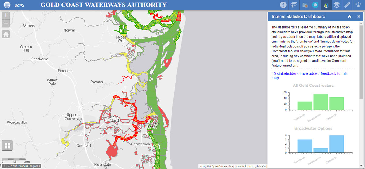
- Real-time collaboration and transparency. The in-app dashboard features reporting that summarises public votes and comments in real time
The Results
Improved decision-making through cloud-based GIS and responsive web app functionality
The web mapping aplication created by AAM for GCWA facilitates effective community engagement. It allows users to add comments and view submissions from others to foster a virtual conversation. This tool facilitates the analysis and reporting of consultation results in real time. It also demonstrates the ability of GIS to promote an enhanced level of stakeholder participation, leading to information that supports improved decision-making and communication. Key outcomes include:
- Improved data categorisation for real time reporting
- Enhanced mapping for location-specific feedback
- Increased accessibility and engagement through a fully responsive solution
- More informed decision making with greater certainty, resulting in better community outcomes
To find out more – email info@aamgroup.com