


Porirua City Council 3D City Models
Dynamic city planning through advanced GIS capability
Porirua is located on New Zealand’s North Island, one of four cities that constitute the Wellington metropolitan area. Porirua City Council (PCC) comprises a community of 52,000 people. PCC’s plan for 2015-25 will see the Council make a significant investment in new infrastructure and city centre development. AAM worked with PCC for many years, improving their geographic information system (GIS) and 3D capabilities to better serve and support the community.
The Challenge
Facilitating community development with accurate spatial data
While preparing for city development works, PCC identified inaccuracies in their spatial data that restricted planning. PCC’s level of detail (LoD) building models were outdated and district plans, based on 2D static map outputs, were not interactive and lacked 3D or height enablement of data.
PCC’s GIS team recognised they needed:
- The ability to approximate 3D buildings using existing models
- Accurate, up-to-date, textured 3D (LoD2) building models—abuilding shell with roof form and building textures
- To provide colleagues and the community with online access to citymodels
- A web GIS viewer that provided easy-to-use analysis tools, layercontrol, map sharing, publishing and printing
The Solution
Aerial imagery and LiDAR processing with 3D web scenes
AAM NZ captured city model data, extracted building models, and provided visualisation tools and training. This was part of AAM’s agreement with PCC and it ensured that final deliverables met cost objectives.
The fully integrated solution to expand PCC’s 3D capability comprised:
- Data acquisition–aerial data captured and delivered via oblique imagery and high density Light Detection and Ranging (LiDAR)
- Development of LoD2 models–AAM processed LiDAR data to extract buildings, ground surface and vegetation. Oblique imagery and LiDAR were further processed, using complex algorithms and photogrammetry methods, to texture the LoD2 models
- Online visualisation tools–AAM used Esri CityEngine 3D technology and web scene templates so staff could visualise, interact with and analyse 3D models
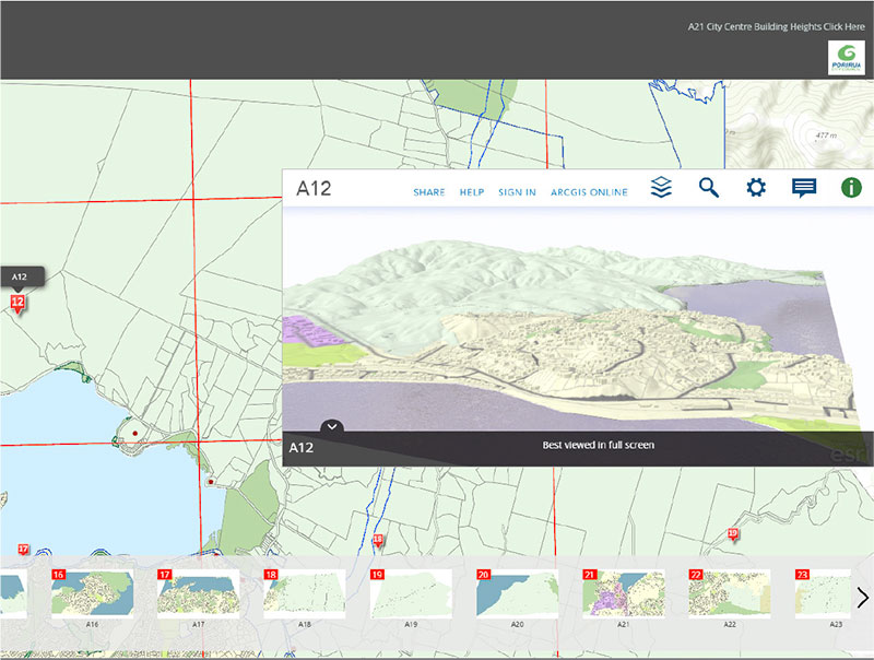
The 2D/3D viewer allows perspective views and enhances council collaboration and presentation.
The Results
Planning a smart city with accurate and up-to-date 3D modelling
As a result of AAM’s solution, the PCC GIS team fully supports new infrastructure and city centre development with precise and detailed LoD2 models.
- Improves interaction with city information by incorporating 2Dand 3D visuals
- Enhances GIS and modelling functionality for better decision-making and planning
- Mitigates impacts by allowing planners to understand theinteraction between the community and proposed developments
- Promotes smart city planning through accurate and current spatialdata
- Facilitates easy access to maps and tools through a fullyresponsive, online platform