


Leveraging AI to create 3D building models
Background
A government organisation responsible for property and land information in Western Australia wanted to respond to their clients’ growing demand for fast and frequent spatial data delivery. They hypothesised that AI could help to achieve this, so they scoped a project to test this theory. The aim of the project was to determine what types of urban infrastructure could be automatically extracted from aerial imagery using AI and Machine Learning (ML) algorithms.
Woolpert are experienced with applying AI and ML algorithms to spatial processes to increase workflow efficiencies. Woolpert also partner with Ecopia, an image analytics company that leverages AI to convert high-resolution images into high-definition vector maps. Based on these strategic advantages, Woolpert were awarded the project.
The Challenge
The targeted area of work included a mix of area densities covering residential, commercial, and industrial locations. Rural areas and vineyard developments were also included. It was unclear how effective AI would be in extracting features from this wide variety of landscapes.
.
.
The Solution
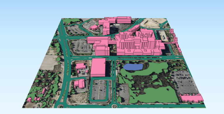
Woolpert utilised 15 cm stereo aerial imagery and a Digital Elevation Model (DEM) over 500 square kilometres in the Perth metropolitan region. Machine Learning algorithms were applied to automatically extract 2D vector layers from these datasets. It was completed with the same level of accuracy as could be achieved manually by a GIS professional.
To include 3D information in the data set, Woolpert generated a Digital Service Model (DSM), supplemented by existing elevation data. This transformed the data from 2D into three dimensions (3D). Using this 3D dataset, Woolpert were then able to add building heights.
The following features were extracted:
- Multilevel Buildings
- Roads
- Railways
- Bridges
- Water bodies
- Swimming pools
- Trees
The Results
It took just 12 days to extract, check and deliver the requested features. Without the use of AI, it would have take approximately 50 weeks to achieve the same results.
By using AI, Woolpert approximates a potential reduction of up to 40% in overall costs.
“Based on the success of this project, we know that an AI-based approach for feature extraction can be put into operation by organisations looking to increase outputs whilst minimising costs. Traditional mapping methods are very linear: the larger the area, the higher the cost. In contrast, AI pushes the unit cost down as the size of the area goes up.”
Michael De Lacy, Mapping Lead, Woolpert
Once the project outputs were finalised, several stakeholder groups reviewed the feature extractions. Their feedback was positive and comprised the following:
- Good consistency and accuracy in the modelling
- Smooth footprints and better definition of shape
- Data appears “ready to use”
- Building footprints broken down into bulk components, indicating a complex shape and varying heights instead of a single outline with a single spot height
- Bridge polygons were presented well
- Successful categorisation of water types
- Very comprehensive and good symbology
Overall the data was accurate and clean. Nothing stood out as a gross error and although some anomalies were spotted, these were resolved with further investigation. The data appeared fit for immediate use.
“The use of AI in projects like this demonstrates clear advantages. Spatial data can be maintained easily and frequently. Woolpert can help businesses and organisations scale their spatial operations to suit their needs in an agile way.”
Michael De Lacy, Mapping Lead, Woolpert