


Reduce field time and lower costs
Traditional survey methods like ground surveys or aerial mapping with a manned aircraft can be a time-consuming process. Not to mention the technical requirements and ongoing maintenance costs.
An unmanned aerial vehicle (i.e. a drone) can help reduce the burden and speed up the data capture and delivery process. Plus, did you know, drone surveying is far more accurate than a manned aircraft survey due to the lower flying heights resulting in more accurate data sets?
The maths is simple. Less time spent capturing data means less labour, which means lower costs. Let Woolpert’s expert and lidar powered UAV surveying team show you how.
Why is drone surveying better?
Cost-effective surveying
Keep project budgets on track with cost-saving UAV surveys. Affordable and quick data capture enable you to survey more sites, more frequently.
Highly accurate data
Receive accurate results, often in the sub-decimeter range. UAVs also fly and capture data at much lower heights making it easier to collect high-resolution, precise images.
Quick turnarounds
Collect millions of data points and get your data in hand quicker with UAVs. All data is processed and ready for delivery on the same day.
GIS & BIM Manager
Aviation
Senior Urban Designer
Local government
National Sector Lead
Architect firm
Civil Engineer
Civil engineering & construction company
Senior GIS Analyst, Spatial Services
Local government
John Gibson
Senior GIS Analyst, Greater Wellington Te Pane Matua Taiao
Choose the industry-leading UAV survey experts
As Australia’s leading UAV aerial mapping specialists, the experts at Woolpert are the team you want by your side for all your drone surveying needs.
Aviation is the cornerstone of Woolpert. We are knowledgeable about Australian aviation and privacy laws and requirements. Plus, we have licensed surveyors on the team ensuring commercial surveys are carried out safely and accurately.
We introduced topographic lidar technology to our clients back in 1998. Today, we employ a survey-grade lidar unit which enables us to create highly accurate and detailed models of the earth’s surface with a height accuracy down to +/- 10cm.
We continue to offer the latest generation sensors to our clients, deployed with professional expertise and experience.
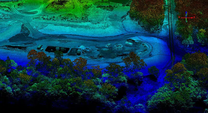
Our drone mapping projects in action

Sunshine Coast Airport Terminal Expansion Survey
Sunshine Coast Airport, represented by Rede Project Consulting, commissioned Woolpert to provide a Feature and Level Survey, 3D Laser Scan and Building Information Model (BIM) of SCA.
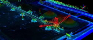
Cross Hybrid Survey Solution for Mining
Woolpert are commissioned to complete recurring survey work for a mining company based in South East Queensland.

Terrestrial Laser Scanning for the University of Melbourne
The University of Melbourne undertook redevelopment work to its site. In particular, the Old Commerce Building was demolished. Due to its façade being of significant heritage value, it needed to be retained whilst the remainder of the building was demolished. It was imperative that the construction works did not cause any movement and potential damage to the façade during the demolition of the building and the erection of a façade retention structure.


GIS & BIM Manager
Aviation
Senior Urban Designer
Local government
National Sector Lead
Architect firm
Civil Engineer
Civil engineering & construction company
Senior GIS Analyst, Spatial Services
Local government
John Gibson
Senior GIS Analyst, Greater Wellington Te Pane Matua Taiao
Reach inaccessible areas with safer drone aerial mapping surveys
Got a site that’s too unsafe to walk on? Maybe the harsh terrain is holding back traditional surveys?
Drones make traditional surveying tasks safer. UAVs can take off and fly from anywhere. This means, previously inaccessible or difficult-to-reach sites like sandpits, quarries or stockpiles are now safe to survey.
Don’t limit your survey efforts anymore. Reach the unreachable and map the unmappable with Woolpert’s highly reliable and capable UAV units.
Frequently asked questions about UAV surveying
There are many factors that determine when we can fly to capture your LiDAR data which can impact cost, such as:
* Air traffic control restrictions
* Weather conditions
* Tidal flows
* Angle of the sun
* Availability of the right aircraft and the right sensor for the job
Other factors that affect the cost of your airborne LiDAR survey include:
* Size of the survey area
* Distance of the survey area from air base
* Terrain conditions
* Level of accuracy required (which in turn is influenced by how you intend to use your LiDAR data)
* LiDAR processing considerations: larger and/or more complex data requires more time, computing power and/or human intervention to process.
Like any flight, our departure times depend on the weather.
We must also factor in our current pipeline of work and equipment availability. But if you need your data urgently, we have different options to meet your need. Talk to us about your project and we’ll work out a solution.
With our efficient LiDAR processing system, you can get your data quickly . Most projects take a few weeks to a few months depending on how much data there is, and how many servers are needed to process the data. We can put more servers on the job if you need the data urgently.
With UAV LiDAR, we can get up to 2000 points per square meter of resolution. With fixed-wing LiDAR we can get about 1-50 points per square meter of resolution, with an accuracy of <10cm. But your project might not need all the data we can get. The level of resolution and accuracy needed depends on the problem you need to solve and how you plan to use your LiDAR data.
We can supply these formats:
TIFF, ECW, RAW (full list coming)
We can translate the data to any format so if your required format is not listed here, get in touch. We can probably deliver in the format you need.
When deciding on whether UAV/drone technology is needed for a project, we consider the location, the size of the area being surveyed, and the resolution required. Some projects don’t need the type of clarity achieved through UAV. Some projects benefit with fixed-wing AND drone LiDAR. What we recommend, depends on the problem and the result you need.
Yes! Geocirrus (link to store) is our catalogue of premium geospatial data. In addition to LiDAR data we have aerial imagery, 3D models and mesh.
We supply the data under AAM’s license or to our clients’ IP.
Once our clients have received and accepted our priced proposal for their project, we initiate a formal project handover. A dedicated project manager talks to our client to clarify that both sides understand the aim and scope of the project. We schedule the appropriate aircraft and sensor to start gathering data, whilst sending regular updates to our clients as each major milestone is reached. Once all the data is captured we send it to our processing team. We process and translate the data into our client’s preferred format, then deliver it via a cloud-based platform or hard disk drive.
Save time, save money and get the data you need, quick.
Get in touch with us for a drone aerial mapping quote.