


Drafting, Modelling & Scan-to-BIM
Functional, geospatially accurate solutions to better inform your projects.
Make informed design, building and maintenance decisions
Woolpert’s experienced modelling team delivers quality, data-driven models you can rely on – a high quality, fit-for-purpose, on-time, on-budget solution.
As your trusted adviser, Woolpert will capture your data and provide you with expert insights and deliverables in multiple formats allowing all stakeholders visibility of their digitised assets. This is not only beneficial for efficiencies in design processes, but also helps in understanding existing site conditions and what can be retained, restored or replaced.
Clean, accurate data minimises risk and mistakes, ensuring you make decisions informed by facts, not assumptions.
Why Woolpert?
Tailored to your budget and requirements
Models can be tailored to your specific requirements and budget, saving time and costs in avoiding unnecessary information. With a point cloud record of all site conditions, additional model detail can be developed at a later date as and when further requirements or finances are realised.
Flexible data delivery options
Models can be delivered in a format that suits your skills and chosen design or viewing platform. We’ll present your model in a way that is easy for someone with or without technical expertise to understand.
Reduced investment overheads
A Woolpert-created model is a lightweight, rationalised and functional representation of captured site data, taking away the need for investment in storage or additional processing hardware to handle heavy point clouds.
GIS & BIM Manager
Aviation
Senior Urban Designer
Local government
National Sector Lead
Architect firm
Civil Engineer
Civil engineering & construction company
Senior GIS Analyst, Spatial Services
Local government
John Gibson
Senior GIS Analyst, Greater Wellington Te Pane Matua Taiao
Your one-stop modelling and Scan-to-BIM service provider
Coordinating a complex project with multiple stakeholders working on different aspects at different stages?
As a full-service provider, Woolpert is able to capture conditions on the ground, at sea or even in the air, with capabilities beyond processing and modelling the data into something consolidated and functional for use.
Woolpert can create a model that will act as your single source of truth, without the need to engage multiple service providers. From start to finish, our data and processes remain coordinated, ensuring quality is maintained throughout all stages, with nothing lost passing through multiple entities.
With an expert team on board, we take the time to understand your needs, ensuring Woolpert delivers the best, most cost-effective, quality solution for you.
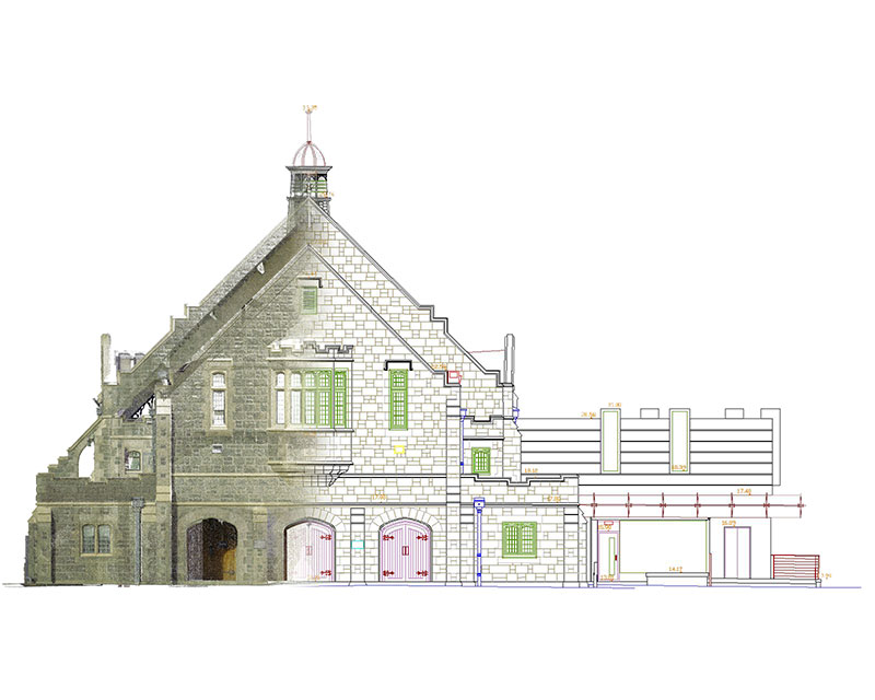
Our modelling projects in action

Sunshine Coast Airport Terminal Expansion Survey
Sunshine Coast Airport, represented by Rede Project Consulting, commissioned Woolpert to provide a Feature and Level Survey, 3D Laser Scan and Building Information Model (BIM) of SCA.

Captains Mountain Wind Farm: LiDAR & Image Survey
Woolpert was commissioned to acquire and process LiDAR and image data over the 180km2 Captains Mountain Wind Farm in Queensland for Vestas Asia Pacific (Vestas).

UGL Train Carriages Modelling
Overview UGL required high-accuracy 3D models of Sydney Trains’ “Tangara fleet” railcar interiors. We initially undertook a four-carriage test study checking the components’ consistency in


GIS & BIM Manager
Aviation
Senior Urban Designer
Local government
National Sector Lead
Architect firm
Civil Engineer
Civil engineering & construction company
Senior GIS Analyst, Spatial Services
Local government
John Gibson
Senior GIS Analyst, Greater Wellington Te Pane Matua Taiao
Simplify stakeholder collaboration through digitised model assets
A model can act as a single source of truth.
Having a geospatially accurate survey model helps to coordinate projects across multiple stakeholders, such as engineers, architects, project and construction managers, contractors and consultants – giving each an understanding of the existing spaces and elements they have to work with.
Make sure teams start on the same page with a validated survey model from Woolpert.
Frequently asked questions about our Drafting, Modelling and Scan-to-BIM services
- We identify and organise field work requirements around safety and site-specific considerations.
- We mobilise our field team to capture your data.
- Your survey data is taken back to the office for processing.
- We draft and/or model according to the defined scope and complete post-authoring QA processes.
- We deliver your data.
It depends. Every project is unique with many variables when it comes to modelling. The primary factors to consider are:
* Required output and format
* Do you need a parametric 3D Object model (e.g. Revit) or “dumb” 3D element modelling, or 2D vector modelling?
* Is a feature survey required? Or plans, elevations, sections, heatmaps or something else?
* Of your requested output what features and level of detail do you need?
* What degree of accuracy or tolerance is required?
* What are the site conditions? Is the building modern or heritage? Is it artchitecturally complex with lots of embellishments and ornate features – or uniform and basic? Is the site occupied with people and/or furnishings, false floors, ceilings and boxing – or is it stripped out, empty and clear of items and furnishings?
Whatever your project demands, AAM have developed a modelling checklist to streamline the process and hone in on our clients’ requirements and to remove any ambiguity. We clearly define scope and expectations so we can deliver on them.
The main constraint to modelling is typically the availability of data. Until we have the processed survey data in our hands, we are unable to progress
Additionally, in some instances we may require further clarification from you in terms of model coordination or alternative contributing information.
In a modelling context, accuracy is relative to the point cloud or input survey data. We can model exact to the point cloud, albeit limited by the relative spread/splash/noise of hte data. Typically we model to the most defined line, on average this is within +/-5mm.
Please note that practical considerations should be taken into account. It is rare that real world elements like walls, floors and ceilings are uniform and regular. These will bend and bow, deflecting over time or subject to wear and tear. While these aspects can be modelled precisely it is impractical because it is time-consuming and expensive.
In a surveying context, Level of Detail only really addresses geometric – graphical – detail, not informational, which is limited to design. There is no specific global standard for defining LOD, so AAM have developed our own interpretation to prescribe it for survey-based modelling; a simplified amalgamation of the BIM Forum and NBS LOD standards, as two of the most widely utilised in design. Our LOD definitions have four incremental tiers – 100, 200, 300 and 400 – broken down into individual key element categories, for example; walls, floors, ceilings, etc.
Utilising our modelling checklist and a browser-based graphical model equivalent we have developed to compliment it, clients gain a better understanding of notional outputs. Understanding what information is relevant to their needs and what detail or tolerances are appropriate ensures a relevant and cost-effective solution
Anything and everything!
Yes, but this is constrained by the authoring software and deliverable format, as these can show different things. You should consider what you need to show and how, before determining the deliverables.
Yes if your software permits. Materials can be assigned directly to objects. If you want something simple and are working in 2D, materials can be assigned annotatively.
This depends on the size and scale of your project and the information required for extraction. We can assign one team or several to meet your deadline. Tell us your required timeline in your initial brief/RFP and we will work out a suitable solution.
We natively author in software such as Autodesk AutoCAD, Civil3D, Revit, Bentley’s Micostation and R.M. & Associates’ Rhinoceros 3D. We can deliver in standard formats that include DWG, DGN, RVT, 3DM and IFC.
We can export into other formats not listed above. If your require a different format, let us know and we will work something out.
- XYZ
- PTS/PTX
- E57
- LAS/LAZ
- VPC
- POD
- IMP
- RCS/RCP
No. A model and a point cloud are natively two different formats and cannot be provided as a single file. Point clouds and models can however be loaded side-by-side within the model’s respective authoring software.
Some viewer packages like Autodesk’s Navisworks allow you to visualise both sets of information outside of the native authoring software. AAM’s Geocirrus web-based platform also allows for this.
Yes. Bespoke QA checklists are defined for each modelling platform and deliverable item. These address the key fetaures of each respective output in what aspects affect the quality of the output. We mandate completed QA checklists which are peer-reviewed by individuals who are not the main project author. If data has been misinterpreted, or if elements are misplaced or missing, this will be captured and reported within the QA process and amended prior to delivery.
Clash detection is possible but only realistically applicable to 3D object modelling. We use Autodesk’s Navisworks platform with set search and clash rule sets in place to semi-automate the process.
Given the nature of survey, clashes may be inherent between certain objects where physical interaction is unknown, for example structural elements obstructed by architectural boxing. All overlapping objects and erroneous clashes will be addressed within our standard QA processes, if not otherwise avoided in the first instance of authoring.
Yes, IFCs can be provided, if appropriate to the deliverable output.
Yes, though in the instance of Revit models specifically, it is advised that this is defined prior to model commencement, else there is a risk this will compromise the model fidelity and cause subsequent rework.
Model content is constrained by the coverage and quality of the input survey data because authoring is based on this. If elements are missing, we will advise you through admission of the survey limitations and limited capture at time of survey, for example we are unable to access a locked room or above a false ceiling.
If the level of detail does not meet your expectations this may be due to data quality. If insufficient data was captured during the survey process, we cannot
fully define an element’s geometry in part or whole confidence. Where these limitations are present – depending on model format – annotations of these issues will be either displayed through documentation or embedded within element metadata, with set filtered views and schedules to highlight to a client in an instance the elements of uncertainty.
We will give you the format year and version that you request. If nothing is specified, we will suggest an output during the proposal stage so you can approve prior to accepting. While format and year are flexible, it is advised that these are determined before modelling begins, else changes may be subject to additional fees for later conversion.
ISO 19650 is a set of standards associated to BIM principles and processes, mostly oriented towards design. There are national annexes to the main parts which are country-specific and will vary from one place to the next.
In terms of survey, direct application of the standards is limited, though we can conform to relevant requirements if they are determined by an issued project BIM Execution Plan (BEP).
It is recognised that where projects are following BIM methodologies and processes as prescribed by ISO 19650, there is a need for establishing existing asset information in supporting development of a project brief, as well as an informed Asset Information Model, or as-built, at the end of a project. AAM supports both these survey activities.
Typical requirements that may be relevant to us as a survey company in conforming to a project BEP, may be in the delivery of information (such as through a Common Data Environment (CDE) platform) or of the content therein of the delivered information. Aspects such as classification, file and object naming, etc. bear the most significance, and are wholly welcomed by AAM.
As default, models issued by AAM’s BIM team follow File and Object naming convention as prescribed by the British Annex of the ISO 19650 Series (BS EN), given the current Australian Annex does not make direct specification on this. Uniclass2015 classification is further embedded within our Revit deliverables to support our clients in remaining compliant to the standard’s requirements for object classification.
At present, this is not a service we provide. This will typically be undertaken by the Project Design Lead or contracted supporting BIM Consultant. AAM are however happy to engage with the respective appointed author in developing the project BEP to document survey inputs and requirements.
This is asset information which is generally not accessible or evident through survey works. COBie information is determined at the point of design and embedded within model elements as appropriate.
This is asset information which is generally not accessible or evident through survey works. COBie information will be determined at point of design and embedded within model elements as appropriate.
We are able to support in the provision of COBie parameters within model elements of Revit deliverables, though the inherent nature of the information will require assignment by the appointed design specialist for valid documentation.
Invest in the data you need
Find out more about our Modelling and Scan-to-BIM services. Schedule a call today.
Tags:
modelling, BIM, 3d Model, 3d Scanner, 3d Designs, Lidar Scanning, Terrestrial Laser Scanning, 3D Design, 3D Scan, Laser Scanning, Point Cloud, 3d Cad, Cad Model, 3d Assets, Bim Construction, 3d Laser, 3d Scanning Services, Building Information Management, bim building information modeling, bim information modeling